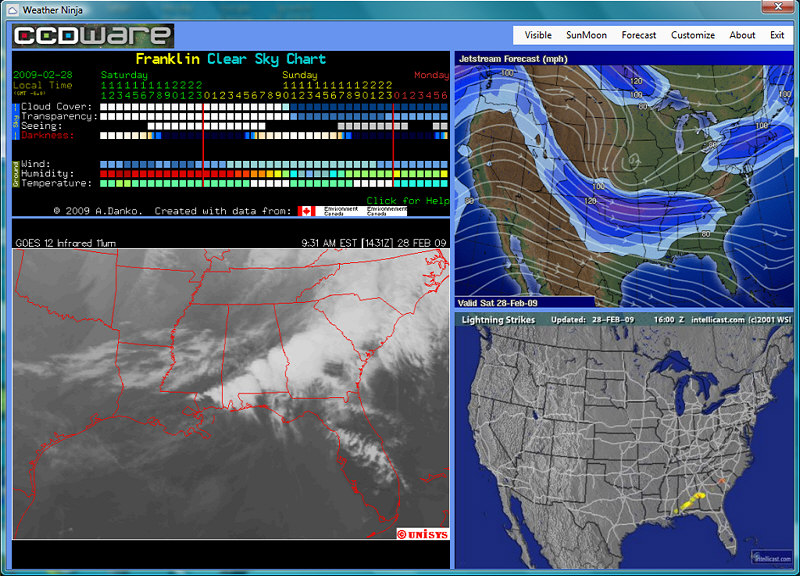
Often when you are planning outdoor events you need good weather information. Certain events, like astronomy programs, also require clear skies. The Weather Ninja is a one-stop weather program available from CCDWare, a company that supplies high quality software for astronomical imaging. This program is free, and does a great job of incorporating many useful features that are all available with a click of the mouse. The "Forecast" tab includes many links to various NOAA sites, as well as current weather conditions. Besides showing a current Clear Sky Chart (see below), the program includes an animated loop of either visible clouds or infrared clouds for the southeast region, the jetstream forecast, lightning strikes (useful for determining where there is severe weather) detailed weather forecasts for the next week, and rise and set times for the sun and moon. The image below is a typical screen shot of the program in action, and is not animated like the real program. You can customize the Weather Ninja for your specific location.
The Clear Sky Chart is a marvel designed by Attilla Danko. You can go to the Clear Sky Chart site for detailed information on how to interpret the chart, but basically what you want to see are all dark or light blue squares for the time of your program or observing session. White or gray squares denote cloud cover or unfavorable transparency, or unfavorable seeing conditions ("seeing" is a measure of atmospheric turbulence). The Clear Sky Chart is included in the Weather Ninja program. The current Clear Sky Chart for Franklin, Tennessee is shown below, and is continually updated. Clicking on the chart will take you to a more full-functioned version, one that you can actually click on each square and be shown the regional view of the sky for that time.
To download Weather Ninja click here and then scroll down the page to Weather Ninja. Below the description of the program there's a "Download" icon that you click to download. After you download and install the program, you may want to click and drag the program icon to your desktop. You will need to customize the program for your specific area. To do so, open the program and click the "customize" tab. To replicate the Weather Ninja chart above, Fill in the information as follows:
City: Franklin Then hit "OK". When you restart the chart, it will come up with the changed settings. For those people living in other areas, click the Clear Sky Chart above and follow the instructions to find the Clear Sky Chart nearest you (or create your own). Once that chart is selected and displayed, right click on the chart, hit properties, and copy down the Sky Clock Code for that chart. Then go back to the Weather Ninja program, click customize, and fill in the appropriate information for your area, including the new Sky Clock Code. If you would like a broader weather outlook, a very nice link for nationwide weather is the NOAA Doppler Radar National Mosaic. To visit this page, click here. You can loop the national Doppler radar, and then click areas to zoom in on the local radar station. One other very handy loop if you do outdoor activities is the Conus (contiguous United States) looping cloud satellite image here. This gives you the cloud movement for the country in the last five hours. You can zoom in if you like.
|